-

1989 325is l 1984 euro 320i l 1970 2002 Racecar
1991 318i 4dr slick top
Euro spec 320i/Alpina B6 3.5 project(the never ending saga)
Vintage race car revival (2002 content)
Mtech 2 turbo restoration
Brilliantrot slick top "build" -
Comment
-
1989 325is l 1984 euro 320i l 1970 2002 Racecar
1991 318i 4dr slick top
Euro spec 320i/Alpina B6 3.5 project(the never ending saga)
Vintage race car revival (2002 content)
Mtech 2 turbo restoration
Brilliantrot slick top "build"Comment
-
Comment
-
Comment
-
Cant win...
I freaked out and thought something that was shipped to my house got stolen, turns out my neighbor had grabbed it and dropped it the next day. So then I started having stuff shipped to my work, well my GC springs and adjusters arrived today but because of the way my work gets the USPS deliveries I wont see it until monday...
I also have to go to a FedEx because a certain amazing package from FL needs a signature. Too much stress just to get my parts lolSimon
Current Cars:
-1966 Lotus Elan
-1986 German Car
-2006 Volkswagen Jetta TDI

Make R3V Great Again -2020Comment
-
Worse is when I literally watch USPS drive by my bay door to the mail box, only to leave a note saying "business is closed or inaccessible, please arrange pickup at PO" :(
FedEx FTW.Comment
-
agreed on fedex. united package smashers are a bunch of shit fucks too.sigpic
Gigitty Gigitty!!!!
88 cabrio becoming alpina b6 3.5s transplanted s62
92 Mtech 2 cabrio alpinweiss 770 code
88 325ix coupe manual lachsilber/cardinal
88 325ix coupe manual diamondschwartz/natur
87 e30 m3 for parts lachsilber/cardinal(serial number 7)
12 135i M sport cabrio grey/blackComment
-
well, it was partly cloudy today when we went over. for purposes of legality, we will say i was sitting in the back deadheading to denver. We were at 34,000 feet so aerial photos are generally pretty shitty from this altitude due to haze and a few clouds in this case. i think you can get the idea though.

we passed by about 30 miles north of Omaha and this photo is the missouri river pointing to the south. The city is to the left outside the frame.

This one is the Platte just about 30 miles west of the city.
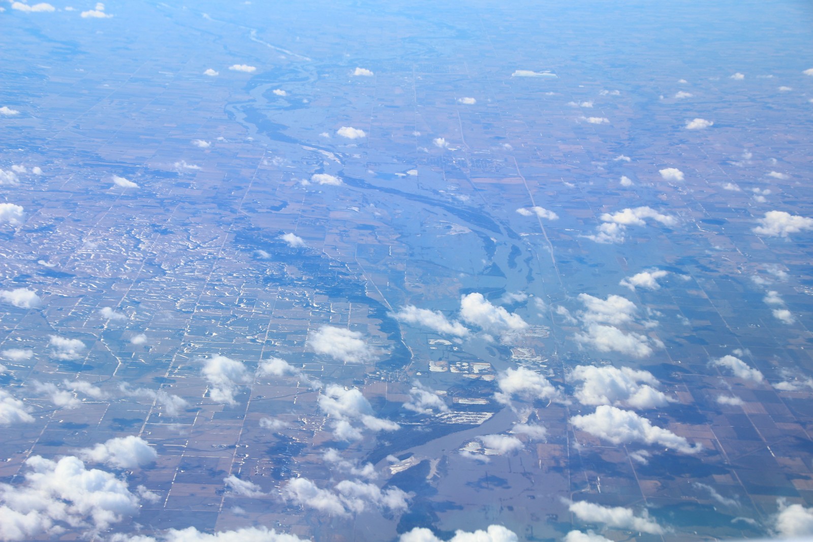
looking north, this is the elkhorn river. you can see it is WAY over its banks at this point. the river normal river path can be seen if you look closely. it is about 15% or less of the width of where it is now
this one is a closeup of the Platte perhaps 80 miles or so west of Omaha. the original path is maybe 10% of the what is flowing in this photo from today.

a little further west, this is the confluence of the platte and the Loupe rivers.

i don't remember if this pic was the North, middle, or South Loupe rivers, but as you can easily see, this one is way over the levees as well.
the last flood as brandon mentions was like 9 years ago. i don't remember which was more severe, but this one is obviously really bad for those that have to endure it.sigpic
Gigitty Gigitty!!!!
88 cabrio becoming alpina b6 3.5s transplanted s62
92 Mtech 2 cabrio alpinweiss 770 code
88 325ix coupe manual lachsilber/cardinal
88 325ix coupe manual diamondschwartz/natur
87 e30 m3 for parts lachsilber/cardinal(serial number 7)
12 135i M sport cabrio grey/blackComment
-
Yea you can see things are really full. Last flood was caused by the core of engineers and any flooding past the missouri was simply back flow off the missouri from it being so full this one is a full on flood from every river and stream. Nothing is coming away unscathed if your’re near water
1989 325is l 1984 euro 320i l 1970 2002 Racecar
1991 318i 4dr slick top
Euro spec 320i/Alpina B6 3.5 project(the never ending saga)
Vintage race car revival (2002 content)
Mtech 2 turbo restoration
Brilliantrot slick top "build"Comment
-
Is it really necessary to quote without deleting the urls of the photos?Comment


Comment